

The Hermeneutical Jew
View publication
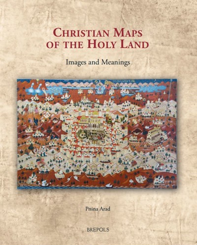
An innovative approach to Christian maps of the Holy Land, exploring their devotional imagery.
“The key case studies are introduced crisply and well, the bibliography is full, and helpful appendices list the toponyms in each of the maps discussed.” (ANDY MERRILLS, in Medieval Archaeology, 65/1, 2021, p. 202)
“(…) sei es doch all jenen empfohlen, die sich für christliche Karten des Heiligen Landes interessieren. (Tim Weitzel, in Historische Zeitschrift, 313/1, 2021, p. 188)
“In all, Pnina Arad gives us a work that advances both knowledge and understanding of the maps of a region central to thought in the Middle Ages and Early Modern periods.” (P. D. A. Harvey, in Imago Mundi, 73/2, 2021, p. 248)
“Christian Maps of the Holy Land is handsome and well-illustrated (…) is a well-developed contribution to the study of Holy Land maps, and it opens some very interesting avenues into cartographic interpretation more broadly. Arad’s wide-ranging approach here will certainly stimulate discussion of and reflection on the ways that our understanding of maps can benefit from examining them as constructed images rather than as records of geographical fact.” (Camille Serchuk, in The Medieval Review, 18/02/2022)
"...a work that advances both knowledge and understanding of the maps of a region central to thought in the Middle Ages and Early Modern periods (P. D. A. Harvey in Imago Mundi, 73:2, 247-248, DOI: 10.1080/03085694.2021.1960052)
“Arad has successfully reimagined the field of Christian map studies and invited a further and deeper study into the specific Christian imagery and ideology present in these maps of the Holy Land.” (Gert Jonathan Naberman, in Reading Religion, 19/02/2023)
“Arad makes a fluent, often enlightening, contribution to the study of the representation of the Holy Land. The appendices will also be a useful resource for future researchers.” (Alfred Hiatt, in Journal of British Studies, 62, 2023, p. 503, 09/06/2023)
Pnina Arad is a research fellow at the Center for the Study of Conversion and Interreligious Encounters at Ben-Gurion University. Her publications focus on visual representations of the Holy Land and the cultural role they have played for different societies from the Middle Ages to the present.
This book offers a way of reading maps of the Holy Land as visual imagery with religious connotations. Through a corpus of representative examples created between the sixth and the nineteenth centuries, it studies the maps as iconic imagery of an iconic landscape and analyses their strategies to manifest the spiritual quality of the biblical topography, to support religious tenets, and to construct and preserve cultural memory.
Maps of the Holy Land have thus far been studied with methodologies such as cartography and historical geography, while the main question addressed was the reliability of the maps as cartographic documents. Through another perspective and using the methodology of visual studies, this book reveals that maps of the Holy Land constructed religious messages and were significant instruments through which different Christian cultures (Byzantine, Catholic, Protestant, and Greek Orthodox) shaped their religious identities. It does not seek to ascertain how the maps delivered geographical information, but rather how they utilized the geographical information in formulating religious and cultural values.
Through its examination of maps of the Holy Land, this book thus explores both Christian visual culture and Christian spirituality throughout the centuries.
List of Illustrations
Abbreviations
Timeline
Introduction
Part I. Iconic Landscape, Iconic Map
Chapter 1. Formation of a Holy Land
Chapter 2. Madaba Map: A Visual Portrait of the Holy Land from the Byzantine Period
Chapter 3. Innovative Western Spiritual Iconographies
Chapter 5. Friedrich III's Cartographical Pilgrimage Imagery
Chapter 7. Icon of a Land
Conclusion
Appendices
Index