Atlas historique du golfe Persique (XVIe-XVIIIe siècles). Historical Atlas of the...
View publication
Because of its thorough examination of all aspects of the Hereford Map, this book is a tribute to the richest, most complicated surviving example of medieval cartography, as well as an essential tool about medieval culture.
“W. hat das Verdienst, die Hereford-Karte jedem interessierten Benutzer in handlicher Weise am Schreibtisch zugänglich gemacht und ein Nachschlagewerk vorgelegt zu haben, das dem Benutzer verwandter ma. Karten und Ihre Inschriften aus dem 10. bis 15. Jh. Mannigfältige Anregungen für die Deutungen an die Hand gibt.” (A.-D. von den Brincken, in Deutsches Archiv, 58, 2002, S. 312)
"This is a rich, solid scholarly volume that will be an essential tool for any future work on the Hereford Map." (R. W. Karrow Jr., in Mapline, 94-95, Fall 2002, p. 10)
"Scholars of the mappamundi will rejoice at this elegant and supremely useful edition. How did we ever live without it?" (E. Edson, in Imago Mundi, 54, 2002, p. 149)
“If you have need of a definitive reference book on an important example of medieval cartography, this is it… Prof. Westrem’s book does an admirable job of both introducing this highly wrought confection of the world, and, more importantly, of making available for a lay audience a thorough and systematic presentation of the wealth of information contained in those inscriptions… This is a gorgeously, and prodiguously illustrated volume that is quite obviously a labor of love…” (D. K. Connolly, in The Portolan, 55, 2002-2003, p. 67)
“The Hereford Map stands as a reliable and imaginative guidebook across the hazards of that beguiling and sometimes alien territory.” (N. Howe, in Anglia, Zeitschrift für Englische Phililologie, 120, 2002, p. 609)
"A pleasure to peruse... and consistently elucidating of its materials, it is a reference work that will be invaluable to every scholar of medieval cartography." (S. Tomasch, in Speculum, 78, 2003, p. 922)
“Scott D. Westrem möchte mit diesem Buch eine Lücke füllen: Eine konsequente Transkription aller Legenden erstellen, und mit deren Übersetzung ins Englischen jenen der Karten-Studiosi, die nicht über ausreichende Kenntnisse in Latein oder im normannischen Französisch verfügen, eine solide Arbeitsgrundlage zu bieten. Dies ist ihm hervorragend gelungen, und seine darüber hinaus geleistete umfassende Analyse der Primärquellen machen dieses Buch zu einem kartographischen Referenzwerk.” (W. Bodenstein, in Cartographica Helvetica, 26, 2002, S. 49)
“L’opera è veramente notevole per molti pregi, in primo luogo per la splendida riproduzione del singolare documento studiato, poi per la completa trascrizione e ordinamento delle 1091 legende (quasi tutte in latino) e illustrazioni riportate nel testo e per la comoda reperibilità delle medesime e per la loro descrizione.” (E. Gabba, in Athenaeum, Studi di Letteratura e Storia dell’Antichità, 90, 2002, p. 300)
“Two things are very clear – Westrem’s linguistic agility, and the depth of his knowledge. He has given us the result of many years of labour; this encyclopaedic book is the most important work on the Hereford Map yet printed, and all future studies must start from it.” (R. Mason, in Medium Aevum, 72, 2003, p. 123)
“Ayant trouvé des solutions originales et fort bien venues à l’édition d’un document peu banal, S. Westrem verse au dossier de l’historiographie de la mappemonde de Hereford un livre qui fera date : le monument qu’il a élevé en l’honneur de ce document exceptionnel est digne du sujet ainsi glorifié.” (E. Poulle, in Bibliothèque de l’Ecole des Chartes, 161, 2003, p. 365)
“Travail quasi surhumain si l'on songe à la nécessaire organisation intellectuelle et matérielle de ces données très variées. L'auteur l'a parfaitement maîtrisé et, à ce seul titre, mérite les plus vifs éloges.” (A. Joris, in Le Moyen Âge, 110, 2004, p. 141)
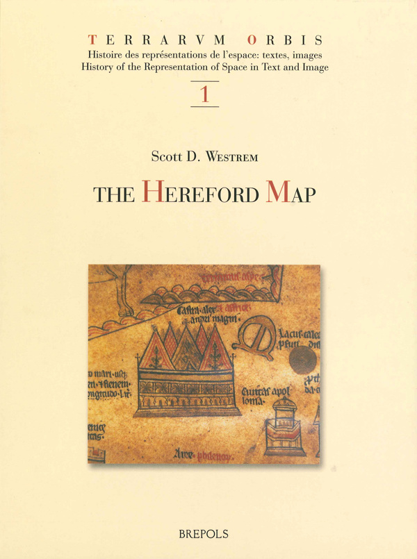
The Hereford Map, a depiction of the inhabited world drawn around 1300, is among the largest surviving examples of medieval mappamundi. It measures 1.59 meters by ca. 1.30 meters (52 1/2 inches by c. 52 inches). On it appear some 1,091 inscriptions, or legends; most of these are placed adjacent to a painted figure of what they identify. They range from simple place-names to long descriptions containing historical, ethnographical, theological and zoological information. The book's introduction offers essential background on the Map's history, sources, and scholarship. Particularly important is an explanation of its close relationship to a text recently discovered - Expositio mappe mundi - a work most composed a century before the Map was made. Right-facing pages contain, for each legend: (1) an exact line-for-line transcription, (2) an edited version of this transcription, and (3) an English translation. Left-facing pages offer commentary on each legend, giving information about its literary and cartographical source, the item it identifies, and textual problems. Included in the book is a colour illustration of the entire Map (approximately 40% of its actual size), as well as detail photographs, taken in January 2001 under special conditions, enabling readers to see each legend precisely, as well as to locate all transcribed and translated text. Because of its thorough examination of all aspects of the Map, this book is a tribute to the richest, most complicated surviving example of medieval cartography, as well as an essential tool about medieval culture.
La carte de Hereford, dessinée vers 1300, est l'un des plus grands exemplaires conservé du genre des mappae mundi. Elle mesure 1,59 x 1,30 m et contient plus d'un millier de légendes et un grand nombre d'images peintes. Ces légendes vont des simples toponymes aux longues descriptions contenant des informations de toute nature. L'introduction de l'ouvrage offre les éléments essentiels relatifs à l'histoire de la carte, à ses sources et aux études qui lui ont été consacrées. L'attention se porte en particulier sur les relations étroites qu'elle entretient avec un texte récemment découvert (Expositio mappe mundi), composé un siècle avant que la carte ait été dressée. Les pages de droite donnent, pour chaque légende, une transcription diplomatique, une édition et une traduction en anglais. Les pages de gauche offrent un commentaire détaillé donnant des informations sur les sources, l'objet identifié, les problèmes textuels éventuels. Le livre contient en outre une illustration abondante: une reproduction en couleurs (environ 40% de sa taille), et des photographies de détails prises en janvier 2001 dans des conditions privilégiées, permettant au lecteur de situer et de lire tous les textes transcrits et traduits. Grâce à un examen approfondi de tous les aspects de la carte, ce livre est un tribut adressé au plus riche specimen de la cartographie médiévale, ainsi qu'un instrument de travail essentiel sur la culture du Moyen Age dans son ensemble.